The nautical industry is undergoing a radical transformation: the transition from assisted navigation to automatic navigation
by Giuseppe Massimiliano Pennisi*
Navigation at sea is an ancient science that has successfully combined natural observation (dead reckoning and celestial navigation) with today’s sophisticated digital technologies. Traditional navigation methods provide the fundamentals every captain must know and use to safely steer a ship, even in the event of a total ‘electronic blackout’. Whereas autopilots used to be simple devices capable of maintaining a fixed course, today’s automatic navigation systems are digital electronic systems that integrate advanced sensors, global connectivity and, more recently, artificial intelligence. An automatic navigation system consists of the following components:
Sensors
– Global Navigation Satellite System (GNSS), which provides position, speed and course;
– Radar, which detects physical obstacles and boats;
– Automatic Identification System (AIS), which transmits motion data and data from nearby ships to ensure compliance with anti-collision regulations;
– Gyrocompass and speed log, which provide heading and speed data;
– Echo sounder, which provides the depth of the seabed;
– Anemometer, which provides wind speed and direction.
Equipment/Systems
– Electronic Chart Display and Information System (ECDIS) processes data from sensors. It displays the nautical chart of the sea area being traversed on the monitor, showing the yacht’s route, waypoints and ships detected by radar. It also “communicates” with the Automatic Radar Plotting Aid (ARPA) to determine and display the safest route to follow.
– Automation system/Autopilot communicates with the ECDIS via the onboard networks to set the course and speed on the yacht’s helm and propulsion system.
Maritime Cyber Security
Excessive reliance on automatic navigation systems poses new risks to safe navigation. GPS signal jamming or spoofing, and attacks on on-board control systems are a reality. For this reason, the architecture of navigation systems is evolving towards ‘hybrid’ systems that integrate Inertial Navigation Systems (INS) capable of determining the yacht’s motion elements using gyroscopes and accelerometers installed on board. Finally, the adoption of AI-based algorithms will enable the filtering of navigation data and the discarding of corrupt or falsified data.
AI is also a tool that can support the space economy and, more generally, industries in the space sector.
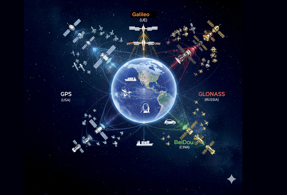
The Global Navigation Satellite System (GNSS)
We are used to calling it GPS, but the reality is much more complex, and the accuracy of our location coordinates results from the ‘fusion’ of data from different satellite constellations. Now, let’s discover the differences between the four satellite positioning systems.
1. GPS – USA
It has been operational since the 1970s and is managed by the US Department of Defence. It uses around 30 satellites and, for civilian purposes, offers accuracy to within a few metres.
2. Galileo – European Union
An EU civil organisation controls it. It uses around 30 satellites and achieves an accuracy of less than 1 metre in free applications.
3. GLONASS – Russia
Developed by the Soviet Union, it uses approximately 24 satellites. It has excellent coverage of the polar regions, but does not achieve the accuracy of the American GPS.
4. BeiDou – China
Developed in 2020, it uses more than 30 satellites in different orbits, ensuring excellent coverage across Asia and the Pacific.
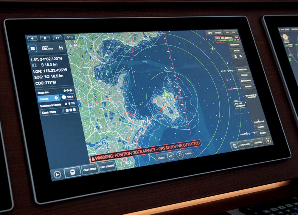
GNSS Spoofing and Jamming
Over-reliance on satellite positioning systems has created new vulnerabilities. Because their signal is relatively weak when it reaches Earth, it can be rendered unusable by employing the following techniques:
1. Jamming – obscuring the signal with electronic noise, which renders the GNSS receiver ‘blind’.
2. Spoofing – the attacker sends a suitably modified signal that ‘fools’ the GNSS receiver into believing it is in a different location.
The use of such techniques can cause a ship to stray off course without the crew immediately noticing

*Giuseppe Massimiliano Pennisi
Giuseppe Massimiliano Pennisi is a Captain, with degrees in Maritime and Naval Sciences from the University of Pisa and in International and Diplomatic Sciences from the University of Trieste. He specialises in telecommunications, radar and electronic warfare. Over the last decade, he has been involved in training defence personnel specialising in telecommunications, IT, cybersecurity and digital forensics. He has set up numerous master’s degrees and university courses in these fields in partnership with leading national universities. He was part of the working group for the creation of a virtual cyber range and of national and international working groups to define professional roles in the field of IT security. To request an assessment or security test, please write to: [email protected].
(Cybersecurity – Automatic navigation systems, 2nd chapter – Barchemagazine.com – Excerpted from Barche, March 2026)